Today's 12.6 mile walk in West Seattle took me through three neighborhoods and to many parks.
Starting near the
Alki Trail and a marker that welcomed me to
Pigeon Point, I walked east and south until coming to the
Duwamish Trail and West Marginal Way SW at the Riverside Mill building and the
Riverside Memorial.


The memorial is on a small plot and is dedicated to the immigrants (mostly from Croatia) who settled here in the late 1800's and early 1900's.
At this point, the Duwamish Trail runs along West Marginal Way and I walked south until I came to the
Port of Seattle's Terminal 105 Park and Duwamish Public Access. This Park is a habitat restoration site and offers great views of the river.


It has a picnic shelter and a hand boat launch. Small boats are warned that the Duwamish is a busy river and that large ships and tugs have limited sight maneuverability - small boats should steer clear of these larger vessels.
Across West Marginal Way, I spotted the Parks Department's facilities maintenance shops and operations division. Just a little further south, I came to
Herring's House Park which runs quite a distance along the Duwamish and offers views of
Kellogg Island.
The park houses the
Yankee Clipper Shore Base, a 5/8 sized replica of the frame of the halibut boats used in this area. Signboards provide a history of the area starting with the Indian villages once on this site, the fisheries that were located here and the immigrants, bootleggers, squatters and counter-culture boat builders who settled here.
The Port of Seattle had planned to build a marine terminal here but archeological remains were found and now it's a park which really appeared to be used by the community. Across Marginal Way, there is a
Duwamish Tribe Longhouse.
Across from the southern end of the park, I came across Puget Way SW and climbed the hill to find a small community of neat homes with large yards. Back down on the Duwamish Trail again, I came to a railroad crossing with a clever sign which really made me look both ways before crossing the tracks.
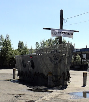
The rest of the walk south along the Duwamish Trail had me passing industrial sites (the Ideal Cement Company proudly displayed the safety award it won from the Portland Cement Association). Levity was introduced by an espresso shop shaped like a ship.
After walking as far as Michigan Street, I veered onto Highland Park Way and climbed the hill noting the
West Duwamish Greenbelt and a small community of neat homes accessible via SW Othello Street.
Turning west onto Holden, a sign welcomed me to the Highland Park neighborhood. I walked north around
Riverview Playfield and north to
South Seattle Community College and then onto the campus but school did not appear to be in session. I will be returning to visit the
Seattle Chinese Garden.
Just north of the college, were a few newer homes, one with some stylish yard art.
Walking north to
Puget Park, I discovered another nice community along 18th Avenue SW.
21st Avenue runs along the west side of
Puget Park and offers an entrance to the West Duwamish Greenbelt walking trails. I'd already walked 12 miles so I skipped the trails today.
It was a hot day and I was ready for a cold drink after this walk.


 The memorial is on a small plot and is dedicated to the immigrants (mostly from Croatia) who settled here in the late 1800's and early 1900's.