

King County International Airport (a.k.a. Boeing Field) extends beyond Seattle so, at times, today's 9.3 mile walk took me into unincorporated King County. There were no signs indicating that I was leaving or re-entering the city but my map indicates that a long stretch of E Marginal Way S is outside the city limits.

Returning to Marginal Way, I was beside the railroad tracks and spotted a pedestrian underpass which would take me to the east side of Marginal Way where I could walk on sidewalks. I was about to take a picture of the underpass when a young woman asked me what I was doing. When I explained, she said I was not allowed to take pictures of any Boeing property and the underpass was Boeing property. She said I could use the underpass but not photograph it. I proceeded south and, in less than five minutes, a security guard drove up to me, got out of his car and told me that he had a report that I had been photographing Boeing property and asked to see my pictures. He indicated that I could not take pictures along Marginal Way but I could take pictures on the other side of the airport along Airport Way. I will report that I saw large buildings, bus stops designed to handle large crowds, the Boeing Headquarters, the Museum of Flight and buildings belonging to the Aviation Technology Department of South Seattle Community College and Highline Aviation High School. I didn't see anything I considered secret or sensitive but I stopped taking pictures until I was on the other side of the airport.
I took S Norfolk Street to Airport Way and turned south to reach the city limit (I had to guess where it was). Turning to walk back north along Airport Way, the wind and passing cars almost blew my hat off. I was distracted grabbing for my hat and tripped over a large cement block. When I got up and resumed my walk, I noticed that a concerned motorist had pulled over and waited to see that I was OK before taking off. I was nice to feel cared for after having felt suspected. Airport Way runs parallel to the railroad tracks.


...and noticing that the Boeing Field Apartments had vacancies. It was a pretty noisy area (mostly from helicopters on this spring morning) so I'm not surprised.


Image Custom Iron Works


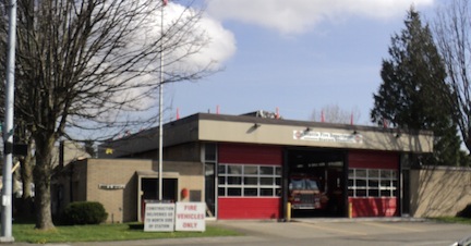
and Fire Station 27.

Wow! What a walk! I, too, wonder what is going on at Boeing! And I'm glad you're OK after that fall!
ReplyDelete