Pages

Wednesday, June 27, 2012

Briarcliff and Southeast Magnolia

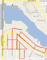
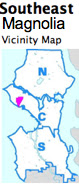
The weather was beautiful today and so were the views as I walked 7.5 miles along the streets of the Briarcliff and Southeast Magnolia neighborhoods. This brought my milage count over 1500 so I'm guessing that I am at least half way to my goal!

I walked streets between 28th and 36th Avenues W from W Smith to Magnolia Blvd and W Galer.

This area surrounds Magnolia Village which has most of the amenities I would expect to find in a small village - cafes, restaurants, shops, a bakery, medical facilities, churches, a fire station, a garden center, a community center, a small beach,

even a cobbler's shop (I did not see a supermarket).

There are a few modest homes and newer condos along the streets near the shops


but homes nearer to Magnolia Bluff are more elegant and many have alley access. This area has sidewalks, curbs, underground utilities and garbage and recyclables appear to be picked up from the alleys.


Walking down 32nd Avenue, I passed under Howe, noticing a stairway up to the street.


Continuing on, I came to a Seattle Public Utility pump station. A path next to it lead to a small beach with a few parking spots.


This area is home to Magnolia Lutheran Church,


a Morman Church (LDS Seattle 1st Ward),


Ascension Episcopal Church,


Fire Station Number 41


and the Magnolia Recreation Center.


I passed many fit looking, well groomed people in the village, dog walkers, gardeners, tradesmen, builders, walkers, bicyclists and young women walking with young children. One small boy asked about my walking stick and looked pretty skeptical when I told him it was to help me balance on uneven surfaces. (I suspect he wanted me to say that I hit things with it.)
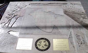
I saw a Magnolia Historical Society plaque,


great views,


beautiful gardens,


impressive homes


and trees painted on a fence.


This was a wonderful walk to mark my half way point.

Tuesday, June 26, 2012

Central District Mann Neighborhood

It felt more like March than June because of the rain during today's 5.6 mile walk in the Mann Neighborhood of the Central District. I walked streets from 23rd to 29th Avenue E between E John and S Union Streets. I knew it was summer because I saw crab apples and cherries on some of the trees but many of my pictures are blurry because I couldn't keep the lens dry.

23rd, Union and Martin Luther King Jr. Way are busy streets but the rest of the streets were quite on this rainy morning. 23rd and Union are commercial houses a power substation


but the rest of the streets are residential. There are some large, older homes


but, more and more, multiplexes appear to be replacing them.


Most of the homes are well kept, a few could use some paint. Many gardens are lovely, a few could use some love. This is a hilly area sloping down to 29th.


This neighborhood is home to the Meredith Mathews East Madison Y (which was advertising swim lessons),


the Ebenezer A.M.E. Zion Church (which serves free lunch every Saturday afternoon),


Mount Calvary Christian Church,


Homer Harris Park (with its imaginative animal sculptures)


and Plum Tree Park.


Along the way, I saw a colorful mural,


staircases, palm trees, tiled streets names in sidewalks (and, unlike on some Ballard streets, the names correspond to the actual street names),


a slide that looked to be coming out of a space ship,


yard art,


garage art


and fence art which reminded me of the Gaudi-designed Park Guell.


The walk was much better than the weather!

Monday, June 25, 2012

North Queen Anne and the Ballard Bridge


I saw quite a bit of Seattle's working waterfront today as I took a 6.2 mile walk in the North Queen Anne neighborhood and crossed the Ballard Bridge. I walked streets from 6th to 15th Avenue W between W Bertona and Salmon Bay.


Walking north across the bridge, I was welcomed to Ballard. There was a steady stream of traffic on the bridge and I saw another walker and a repair crew.


I observed, working boats, crew teams and pleasure craft. I had to stop when the bridge opened for a sailboat with a tall mast.


Underpasses and overpasses took me back to Queen Anne where I walked near the waterfront observing the Ship Canal Trail (walking and biking) as it paralleled some old railroad tracks and ran through Foss (maritime) facilities.


Climbing up the hill, I entered a residential area with steep streets and lots of staircases. Homes got grander the higher I climbed.

Along the way, I passed a Pacific Science Center Exhibit Shop, a Rapid Ride Stop (the King County website indicates that service on this D Line will start in the fall of 2012),


some lovely gardens


and what looked like the end of the railroad line.


I got a real workout on the hills and staircases.